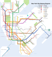
A transit map of the New York City Subway, one of the oldest and most extensive public transportation systems in the world. It has 468 stations in operation and 209 mi (337 km) of routes, with a total of 842 miles (1,355 km) in track. It is the busiest rapid transit rail system by annual ridership in the Western Hemisphere, and fifth busiest in the world. The system's stations are located throughout the boroughs of Manhattan, Brooklyn, Queens and the Bronx. Staten Island has its own rail line which is not part of the system, but is included in the map as well.
Map: CountZ


